Shin-etsu Trail Day-by-Day Highlights, Sections 1 - 5.
The Shin-etsu Trail in its fullest is a 110km hiking trail stretching through Japan's Nagano and Niigata prefectures, and located 2-hours by bullet train from Tokyo. The trail winds over and around mountain peaks, through Japanese villages, and has spectacular views and beautiful forest and wetland along the way. It includes travelling through alpine villages and landscapes, starting from Mt Madarao.

Our Hiking Trails Pty Ltd Shin-etsu Trail walking package, includes walking the first 5 daily sections over 5-days of walking, and a summary of the daily section highlights and walk profile are included below. Whilst the walk is set-up to also allow camping in tents, our self-guided walking packages are designed to be a little more comfortable, with daily drop off to and pick up from your accommodation staying in local minshuku and ryokan, and with the occasional Onsen to soak in along the way, plus incredible, local, seasonal Japanese meals.
Section 1; Mt Madarao to Aka Ike Pond
- Section length 8.5km, time required approximately 6-hours walking
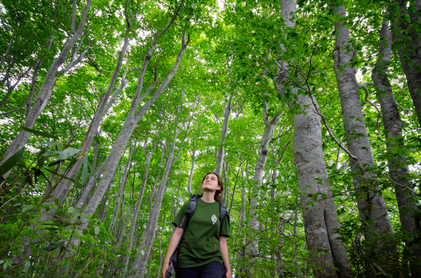
- If the weather is nice, the view from Mt. Madarao provides a complete picture of the Shin-etsu Trail. The terrain and plants are quite varied in Section 1. There are many ups and downs on the Trail, so set a comfortable pace and preserve your strength
- This section starts at Mt Madarao and winds its way up and through what is the Madarao Ski Area in winter.
- From Mt Madarao summit a 10-minute hike will take you to Mt Daimyojin-dake, a sub-peak with excellent lakeviews.
- Great mountain and lake view along the way.
- Pass through the Hakama Shitsugen wetland.
- Section 1 finishes at the picturesque Aka Ike pond (toilets and water).
- Limited shade, so ensure sunscreen, hat, and lots of water.
Section 2; Aka Ike Pond to Wakui Village
- Section length 11.2km, time required approximately 5-hours walking
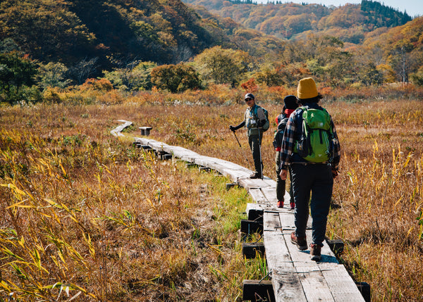
- The Trail in this section starts at Aka Ike pond and travels through Numanohara wetlands and Lake Nozomi. A succession of flowers bloom in the wetlands through the seasons, making for a new experience regardless of how many times you hike the section. The terrain here is rather gentle, and even those not confident about their physical strength can enjoy hiking at the section at their own pace here.
- Travel through beech forest and later larch forest, and near the end of the days walk, along a farm road.
- Toilets at several points along the walk.
- Walk across boardwalks through the Numanohara wetland.
- Tranquil Lake Nozomi and Wakui Shin Ike ponds.
- Again, there are many spectacular view points along the way.
- Limited shade, so ensure sunscreen, hat, and lots of water.
Section 3; Wakui to Mt Hotoke ga Mine Trailhead
- Section length 12.7km, time required approximately 6-hours walking
- This section is full of highpoints, including historical sites such as Tomikura Tōge pass and the ruins of Taishojin; Mt. Kuroiwa, a beautiful nature feature and itself a designated natural monument; Katsura Ike pond with beautiful autumn leaves, and more. There are portions of ongoing travel through the forest, but also changing areas of beech and cedar forests and wetlands. There is a small, roofed shelter on Mt. Kuroiwa that offers not only a good spot for a break, but a sweeping view of the Iiyama basin and Chikuma River.
- Tomikura Tōge pass and Taishojin Ato ruins
- Beautiful ponds Sobu no Ike, Katsura Ike and Kitafuru Ike
- Toilets 9km into the walk, and at the finish point
- Finishing the day with a walk across a ski area
Section 4; Hotoke ga Mine Trailhead to Sekida Tōge pass
- Section length 8.5km, time required approximately 5 to 6-hours walking
- The center of the Sekida Mountains part of the Shin-etsu Trail, with a series of ups and downs toward the main peak, Mt. Nabekura. The section features beautiful beech forests, and excellent views of the Iiyama basin and the Sea of Japan.
- Beech forest, ridgeline, and mountain passes.
- Views of the Sea of Japan in the distance
- Kyoboku no Tani (“Valley of Giant Trees)
- Yoshihachi Ike pond and Chaya Ike pond
- Toilets available at several points along the days walk
Section 5; Sekida Tōge Pass to Busuno Tōge Pass
- Section length 12.4km, time required approximately 6-hours walking
- The beech trees here have curved trunks from the great weight of snow pressing on them in winter; it can feel like a competition straddling them and trying to pass over them. This is the habitat of the Forest Green Tree Frog and Japanese black salamander, as well as the native habitat of the rare nabekura zazensoui plant. When the weather is good, the sea of Japan and even distant Sado Island can be seen from Maki Tōge pass.
- Several mountain passes and local villages
- Chaya Ike pond and Maboroshi no Ike pond (surrounded by beech forest)
- Toilets and rest stops at several points along the walk.
With a Hiking Trails Pty Ltd Shin-etsu Trail package, each day you'll be dropped at the trailhead (with a packed Japanese picnic lunch) and collected at the finish, ready to be taken back for a shower, maybe an Onsen, a delicious meal, and a comfortable futon.